


Risk Overview
Seven-day Weather Risk Overview
The graphic shows the daily risk summary for 7 days. Daily risk is based on highest risk factor for that day.
|
|
|
|
|
|
|
|
|
|---|---|---|---|---|---|---|---|
| risk level |
|
|
|
|
|
|
|
Risk Factors
The graphic shows the weather factors that have some risk for the next 7 days. Click on the colored boxes to see what the risk factors is based on and what impact it may have.
| Wind |
Wind: risk level 0
|
Wind: risk level 0
|
Wind: risk level 0
|
|
|
Wind: risk level 0
|
Wind: risk level 0
|
|---|---|---|---|---|---|---|---|
| Excessive Rainfall Risk |
Excessive Rainfall Risk: risk level 0
|
Excessive Rainfall Risk: risk level 0
|
|
|
Excessive Rainfall Risk: risk level 0
|
||
| Grassland Fire Danger Index (GFDI) |
Grassland Fire Danger Index (GFDI): risk level 0
|
Grassland Fire Danger Index (GFDI): risk level 0
|
Grassland Fire Danger Index (GFDI): risk level 0
|
Grassland Fire Danger Index (GFDI): risk level 0
|
|
Grassland Fire Danger Index (GFDI): risk level 0
|
Grassland Fire Danger Index (GFDI): risk level 0
|
No impact in 8 other categories: Tornado Risk, Severe Thunderstorm Risk, Extreme Cold Risk, Fog Risk, WinterStorm, Blowing Snow, Frost/Freeze Risk, Lightning Risk
Monday: Wind
1:
Risk Map


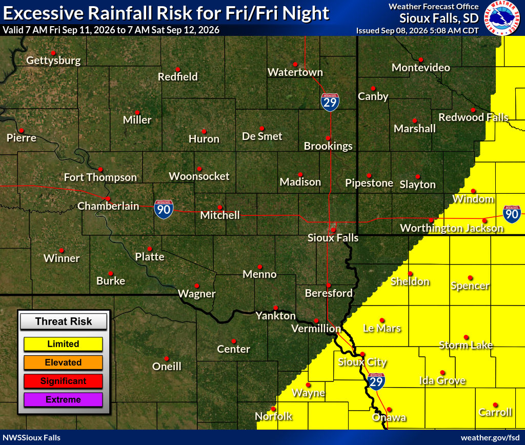
Sunday: Excessive Rainfall Risk
1: 1
Isolated flash floods possible. Most flooding will be localized to areas that can experience rapid runoff with heavy rainfall.
Determining Risk
We base this risk on the excessive rainfall outlook from the Weather Prediction Center. You can learn more about excessive rainfall on their website.
Risk Map

Risk Levels
| risk level name | risk level description |
|---|---|
|
1:1
|
Isolated flash floods possible. Most flooding will be localized to areas that can experience rapid runoff with heavy rainfall. |
|
2:2
|
Scattered flash floods possible, some potentially significant. Most vulnerable are urban areas, roads, small streams, and washes. |
|
3:3
|
Numerous flash floods including some significant events likely. Many streams may flood, affecting nearby residential and urban areas. |
|
4:4
|
Widespread, severe flash floods expected. Events could occur in areas that don't normally flood. Lives and property in greater danger. |
Tuesday: Grassland Fire Danger Index (GFDI)
1: 1
GFDI=High: Unfavorable weather conditions and low moisture content of grasses and other dry organic material on the ground, indicating that there is a high potential for fire to spread. Outdoor burning should be restricted to early morning or evening hours when wind speeds are usually lower and the relative humidity is higher. Burning is still favorable for well-planned burns by experienced land management personnel. Difficulty of fire suppression: Headfire attack generally successful with water.
Risk Map

Risk Levels
| risk level name | risk level description |
|---|---|
|
1:1
|
GFDI=High: Unfavorable weather conditions and low moisture content of grasses and other dry organic material on the ground, indicating that there is a high potential for fire to spread. Outdoor burning should be restricted to early morning or evening hours when wind speeds are usually lower and the relative humidity is higher. Burning is still favorable for well-planned burns by experienced land management personnel. Difficulty of fire suppression: Headfire attack generally successful with water. |
|
2:2
|
GFDI=Very High: Very poor weather conditions and very low moisture content of grasses and other dry organic material on the ground, indicating that dangerous burning conditions exist. Fires will spread rapidly and show erratic behavior. Outdoor burning is not recommended other than for experienced land management personnel. Difficulty of fire suppression: Direct headfire attack will become increasingly difficult. Spot fires are more likely. |
|
3:3
|
GFDI=Extreme: Extreme weather conditions and very low moisture content of grasses and other dry organic material on the ground, indicating that critical burning conditions exist. All fires have the potential to become large and spread quickly and become erratic with extreme fire behavioral characteristics. Difficulty of fire suppression: Direct attack on a headfire will generally fail. Back burn from a secure good line with adequate manpower and equipment. Flanks may become more difficult to control in shifting or erratic winds. Spot fires are likely. |
|
4:4
|
GFDI=Extreme (High-End/Rare): Extreme grassland fire weather conditions that are rarely experienced in our area. Very high winds and low humidity with very dry cured grasses. Any fire that starts will spread rapidly and be almost impossible to control. Fire suppression: Direct attack will likely fail, especially in heavy fuel loads. |
Saved locations
Loading the risk data......