



Risk Overview
Seven-day Weather Risk Overview
The graphic shows the daily risk summary for 7 days. Daily risk is based on highest risk factor for that day.
|
|
|
|
|
|
|
|
|
|---|---|---|---|---|---|---|---|
| risk level |
|
|
|
|
|
|
|
Risk Factors
The graphic shows the weather factors that have some risk for the next 7 days. Click on the colored boxes to see what the risk factors is based on and what impact it may have.
| Extreme Heat Risk |
|
|
|
|
|
|
|
|---|---|---|---|---|---|---|---|
| High Surf Risk |
|
|
|
|
|
|
|
| Rip Current Risk |
|
|
|
||||
| Fog Risk |
Fog Risk: risk level 0
|
Fog Risk: risk level 0
|
|
|
|||
| Wind Risk |
Wind Risk: risk level 0
|
Wind Risk: risk level 0
|
Wind Risk: risk level 0
|
Wind Risk: risk level 0
|
|
Wind Risk: risk level 0
|
Wind Risk: risk level 0
|
No impact in 9 other categories: Lightning Risk, Extreme Cold Risk, Marine Hazard Risk, Tornado Risk, Fire Weather Risk, Hail Risk, Thunderstorm Wind Risk, Excessive Rainfall Risk, Severe Thunderstorm Risk
Thursday: Extreme Heat Risk
3: Significant
Heat exhaustion or heat stroke likely with prolonged exposure.
Determining Risk
We base this risk on local weather office temperature and/or heat index forecasts.
Risk Map

Risk Levels
| risk level name | risk level description |
|---|---|
|
1:Limited
|
Heat exhaustion possible with prolonged exposure. |
|
2:Elevated
|
Heat exhaustion likely with prolonged exposure. Heat stroke possible. |
|
3:Significant
|
Heat exhaustion or heat stroke likely with prolonged exposure. |
|
4:Extreme
|
Dangerously hot conditions could quickly result in heat exhaustion or heat stroke. |


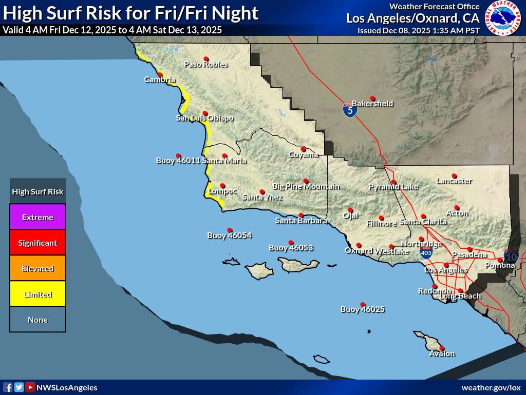
Thursday: High Surf Risk
1: Limited
Breaking waves can wash people off beaches and rocks.
Determining Risk
We base this risk on local weather office surf height forecasts.
Risk Map

Risk Levels
| risk level name | risk level description |
|---|---|
|
1:Limited
|
Breaking waves can wash people off beaches and rocks. |
|
2:Elevated
|
There is an increased risk for ocean drowning. Breaking waves can wash people off beaches and rocks, and capsize small boats near shore. |
|
3:Significant
|
There is an significant risk for ocean drowning. Large breaking waves can cause injury, wash people off beaches and rocks, and capsize small boats near shore. |
|
4:Extreme
|
Powerful waves and currents will pose an exceptional risk of ocean drowning and damage to coastal structures like piers and other jetties. Large breaking waves can cause injury, wash people off beaches and rocks, and capsize small boats near shore. |




Thursday: Rip Current Risk
2: Moderate
Life-threatening rip currents are possible in the surf zone.
Determining Risk
We base this risk on local weather office rip current risk forecasts. These consider swell height/period, wind speed/direction, and other parameters.
Risk Map

Risk Levels
| risk level name | risk level description |
|---|---|
|
2:Moderate
|
Life-threatening rip currents are possible in the surf zone. |
|
3:High
|
Life-threatening rip currents are likely in the surf zone. |


Friday: Fog Risk
3: Significant
Fog with visibilities less than or equal to 1/4 mile.
Determining Risk
We base this risk on local weather office fog and visibility forecasts.
Risk Map

Risk Levels
| risk level name | risk level description |
|---|---|
|
1:Limited
|
Fog with visibilities less than or equal to 1 mile. |
|
2:Elevated
|
Fog with visibilities less than or equal to 1/2 mile. |
|
3:Significant
|
Fog with visibilities less than or equal to 1/4 mile. |
|
4:Extreme
|
Fog with near zero visibilities. |

Sunday: Wind Risk
1: Limited
Breezy conditions could blow around unsecured items and result in hazardous driving conditions for high-profile vehicles.
Determining Risk
We base this risk on local weather office wind speed/gust forecasts.
Risk Map

Risk Levels
| risk level name | risk level description |
|---|---|
|
1:Limited
|
Breezy conditions could blow around unsecured items and result in hazardous driving conditions for high-profile vehicles. |
|
2:Elevated
|
Windy conditions could damage outdoor items and result in hazardous driving conditions for high-profile vehicles. |
|
3:Significant
|
Very windy conditions may down trees and power lines, causing property damage or power outages. Cross winds can make driving difficult, especially for drivers of high profile vehicles and vehicles towing trailers. |
|
4:Extreme
|
Extremely windy conditions will cause localized property damage, down numerous trees and cause widespread power outages. |
Saved locations
Loading the risk data......